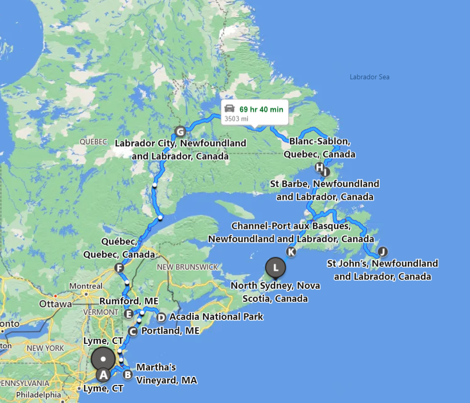
Monday (August 22nd) woke up early, departed Connecticut 4:00am. Drove Interstate-95 to Woods Hole, Massachusetts. Parked the car, and took the shuttle bus to the ferry terminal. The ferry ride was brief, and arrived on Martha’s Vineyard by 8:00am.
Sky was overcast with scattered showers, the air was humid. Local bus from Vineyard Haven to the hostel cost $6 for the six-mile drive; Uber was $30. The bus fare was not inexpensive, and perhaps the cost explains why many people don’t use public transportation. I was told that long-time locals often hitchhike. Out of stubbornness, walked to the hostel, and checked in to HI Martha’s Vineyard at 10:00am.
Hostel staff lent me a bicycle, and I rode 25-mile “triangle” loop to Edgartown, Oak Bluffs, and West Tisbury. There were bicycle paths for most of this loop, protecting me from the dense automobile traffic. Riding on the side of the road felt dangerous in comparison.
The evening was humid; the bedroom windows were open, but there was no fan or air conditioner; felt sticky and clammy; uncomfortable sleeping weather.
Chappaquiddick Island lies on the eastern side of Martha’s Vineyard, and is often remembered for the July 1969 incident, when Senator Ted Kennedy drove off the road, and led to the drowning death of his passenger, Mary Jo Kopechne; Kennedy left the scene of the accident. Following a grand jury investigation in 1970, no indictments were issued.
The 1975 summer blockbuster film, Jaws, was filmed on Martha’s Vineyard, despite the movie’s fictional location, Amity Island, off the New England coast.
This was my first visit to Martha’s Vineyard; my impression is that it’s overrated and expensive; perhaps only a cost-agnostic person would be immune. If you are considering a visit, I might suggest making a day trip; take the 6:00am ferry to the island and the 9:00pm ferry off the island; allows plenty of time to explore coffee shops, restaurants, and shopping.
Weather forecast for Tuesday (August 23rd) called for afternoon thunderstorms. After morning tea, began walking back to the ferry terminal. During the six-mile walk, the sky opened up, and I got soaked, including my backpack and its contents. I started running – not sure why – because I just seemed to get wet more quickly. While running, the zippers opened on my backpack, and I thought that I lost my prescription eyeglasses (which I wear in the evening). I became angry and yelled out-loud, berating myself, before I found the eyeglasses in another backpack pocket.
I stepped off the bike trail onto the main road. Despite being soaked, I remained too stubborn to pay $6 for the six-mile bus ride to the ferry. A car approached, a late model Toyota Yaris. I stuck out my thumb – my first time hitch hiking – just like a local.
I was picked-up by an Asian-American resident, studying landscape design; the kindness of strangers. Perhaps she felt sorry for me, looking cold and wet, and perhaps determined that I was not a threat. She dropped me off at an intersection near the ferry terminal, as the streets were flooded, following the morning thunderstorm.
I handed my ferry ticket to the purser, to board the ferry; the ticket was dripping wet (I’m surprised that the ink didn’t run off); the ticket wouldn’t scan; he waved me on-board.
I went to the men’s room, and dried my shoes, t-shirt, backpack, and pants under the hand dryer; even the five-dollar bill in my pocket was completely soaked. I considered removing and drying my underwear, too. There’s nothing quite so uncomfortable as sitting in wet underwear, or perhaps, seeing a naked man drying his underwear in a public bathroom.
Took the shuttle bus back to the parking lot; emptied the backpack onto the floor and the front seat, and put the car heater on high, in attempt to dry everything out.
Drove Interstate 495, looping west of Boston, to avoid dense traffic; stopped at Starbucks in Seabrook New Hampshire to catch-up on laptop work. Checked into a last-minute AirBnB at Hampton Beach New Hampshire. My family used to vacation here, at Hampton Beach State Park, when I was a teenager. Seabrook nuclear power plant is visible from the beach. AirBnB was one block behind the boardwalk, and included free parking. In the afternoon, walked the board walk and beach; the water temperature was 65-degrees. Due to its seasonal nature, lodging in Hampton Beach is not inexpensive; after a “shitty” morning, I wanted a hot shower, and to wash my clothes. Watched last episode of Only Murders in the Building.
Wednesday (August 24th), exercised with kettlebell, and did some writing and laptop work, before departing AirBnB. Stopped at the local Whole Foods Market in Portsmouth. Stopped at LL Bean (flagship) store in Freeport; I was looking for a canvas tote bag. Drove back towards Conway New Hampshire, and checked into Conway Hostel. Prefer staying at hostel versus an AirBnB; appreciate the sense of community and meeting other travelers. It wasn’t a bad hostel, but it was underwhelming.
Thursday (August 25th), stopped at local Honda dealer in Portland Maine, to check tire pressure; then stopped at local library, and joined an IT conference call. In the afternoon, checked into Black Elephant Hostel in Portland. It’s a great hostel; clean and modern; nice sense of community; walking distance to tourist attractions on the wharf.
Friday (August 26th) drove to Acadia National Park, outside Bar Harbor Maine, considered the crown jewel of the North Atlantic coast. The park was crowded, and it started raining. Put on my rain jacket and hiked 3.5-mile loop along Jordan Pond. In the afternoon, drove west and got some work done at Blue Hill Library.
Drove over Deer Isle Bridge, a unique suspension bridge over the Gulf of Maine, linking Deer Isle to the mainland, and checked-into Deer Isle Hostel, a unique, off-grid property. The hostel isn’t for everyone; to begin, it’s 50-miles from Acadia National Park; and I considered not staying for the second night of my reservation. The hostel boasts an outdoor shower; the water is very hot, by coiling the hose through a large pile of woodchips; it also had an outhouse, using sawdust to facilitate composting fecal waste. The main building was built by Dennis, the owner, by harvesting trees from the property, and subsequently cutting, and planing the boards. Dennis was motivated by the Forest Hostel, in Brunswick Georgia.
Saturday (August 27th) returned to Acadia National Park at 6:00am sunrise, to avoid the crowds, and hiked 6.5-mile loop trail, linking Acadia’s six summits: Bald Peak, Parkman Peak, Gilmore Peak, Sargent Mountain, Penobscot Mountain, and Cedar Swamp Mountain.
Before hiking, used the vault toilet, which is better than the urge to take a dump on the trail. I’m likely scarred by using the squatty-potty in India or China; smell it before you see it. Concerned that I’ll drop keys, iPhone, or credit card down the toilet; how would you recover?
It rained overnight, and despite the forecast for sunny skies, the mountain was shrouded in fog. The hiking was slow, 2-miles per hour. Above the tree line, I couldn’t see the cairns that marked the hiking trail; the granite rocks were wet and slippery; it was difficult to find foot holds along the gnarled tree roots, as I didn’t want to roll or sprain an ankle. In the afternoon, stopped at local library in Ellsworth for laptop work.
Sunday (August 28th), drove from Deer Isle to Augusta; stopped at local Starbucks to work on laptop; drove onward to Rumford, to visit family. My aunt and uncle gave me a tour of the town, including Roxbury Pond (where we vacationed as children), and nearby Rumford Falls, and the large paper mill.
Monday (August 29th), my uncle made crepes for breakfast, one of his specialties, served with fresh fruit and whipped cream. I could probably eat my bodyweight in crepes. In the afternoon, helped out in the yard, dinner at a local restaurant, followed by card games.
Tuesday (August 30th), drove 250-miles north to Quebec City, Quebec, located on the Saint Lawrence River; the weather was hot and humid; 90-degrees; the skies were unstable, and threatened thunderstorms. Stopped at the local outdoor store, to purchase a Canada National Park pass, and stopped at Scotia Bank, to get some Canada dollars, just in case. US dollar is trading at a 23% premium; when I lived in Ottawa (2007-2011), the US dollar was trading at par. Checked into local hostel, with free parking.
Wednesday (August 31st), wanted to go running at the local park in the morning, but unstable skies threatened thunderstorms. Got some writing done in the morning, followed by two private equity conference calls. Stopped at post office in the afternoon, to mail a thank you note to my aunt and uncle; stopped at local grocery store, too. In late afternoon, drafted a policy document on internal controls for a colleague.
Thursday (September 1st), woke up early; the weather was cooler and less humid after a cold front passed through overnight. Threw around the kettlebell before doing some laptop work. Drove 250-miles north on highway 138, along the northern shore of the Saint Lawrence River, driving from Quebec City to Baie-Comeau, in Quebec province.
Driving along the Saint Lawrence River was amazing; the sun reflected like strands of gold on the water. The river is 1,900-miles long, and connects the Great Lakes to the North Atlantic.
Approached the Saguenay River at Baie Saint Catherine, and took the ferry across to Tadoussac. The river runs deep and cold; beluga whales breed at the river’s mouth.
Checked into AirBnB in the afternoon, and spoke with Max, another AirBnB guest. He emigrated from Haiti to Montreal, and is a social worker in Baie-Comeau. We shared dinner together; he was a delightful host; he made plantains, a starchy vegetable that resembles a large banana, however, it’s consistency and flavor resembles that of a potato.
Friday (September 2nd), drove from Baie-Comeau to Labrador City; eight hours (0600 EDT – 1500 ADT), 375-miles on Highway 389; one-third of the highway was un-paved, gravel road; traffic was sparse, mainly tractor trailers and logging trucks. The northern terminus of the highway is accident prone with sharp curves; locals say that you can see your own taillights. There was a dead moose on the side of road, likely due to impact with an automobile. Billboards caution drivers about the moose hazard, and also report annual fatalities due to moose impact; the average male moose is six feet tall and may weigh up to 1,500 pounds.
Highway 389 was built in-part by Hydro Quebec, which operates three hydro-electric plants on the Manicougan River; Jean-Lesage generating station (MANIC-2), René-Lévesque generating station (MANIC-3), and Daniel-Johnson dam (MANIC-5), which backs up to the Manicougan Reservoir, known as the “eye of Quebec” formed by an impact crater and visible from space.
Passed through ville de Gagnon, a ghost town, that served the iron ore mining community between 1960 and 1985. Signs of the main street, street curbs, and sidewalks remained visible. ArcelorMittal now operates iron ore mining at Mont Wright, Quebec.
No AirBnB or hostel in Labrador City; checked into Dexter Inn, essentially, a working hotel for the miners; there were no vacancies in the other, more upscale, nearby hotels.
Newfoundland and Labrador was the last province to join Canada in 1949. For reference, Alaska became 49th state in January 1959; Hawaii became 50th state in August 1959.
Canada has ten provinces; I have visited each province: Ontario, Quebec, Nova Scotia, New Brunswick, Manitoba, British Columbia, Prince Edward Island, Saskatchewan, Alberta, Newfoundland and Labrador. Canada has three territories; I have not visited the later two: Yukon, Nunavut, Northwest Territories.
The territories are north of 60º latitude, and while they account for 40% of Canada’s land mass, they represent only 3% of Canada’s population. Provinces exercise constitutional powers in their own right; territories exercise delegated powers under the authority of the Parliament of Canada.
Saturday (September 3rd), drove from Labrador City to Happy Valley Goose Bay, six hours (0700 – 1300 ADT), 325-miles along the fully-paved, Highway 500; traffic was sparse. Checked into AirBnB, set-up mainly for field workers. The local military base has an 11,000 foot runway, which serves as an alternate landing site for the space shuttle.
Sunday (September 4th), drove from Happy Valley Goose Bay to Blanc Sablon Quebec, eight hours (0600 – 1400 NDT), 375-miles along Highway 510; traffic was sparse. While the northern terminus has dense black spruce, the southern terminus has few, if any trees, likely due to prevailing ocean winds.
There were few communities in Labrador, some comparison points:
– Newfoundland & Labrador: 523,000 | 3.5 per sq. mile | 157,000 sq. miles
– Canada: 39-million people | 11 per sq. mile | 3.9-million sq. miles
– United States: 332-million people | 87 per sq. mile | 3.8-million sq. miles
– Texas: 29-million people | 114 per sq. mile | 269,000 sq. miles
Monday (September 5th); happy Labour Day! Woke up early, and took two-hour ferry across the Strait of Belle Isle from Blanc Sablon to St Barbe, Newfoundland. Newfoundland has its own time zone, established when it was an independent dominion; 30-minutes ahead of Atlantic time, and 30-minutes behind Greenland time.
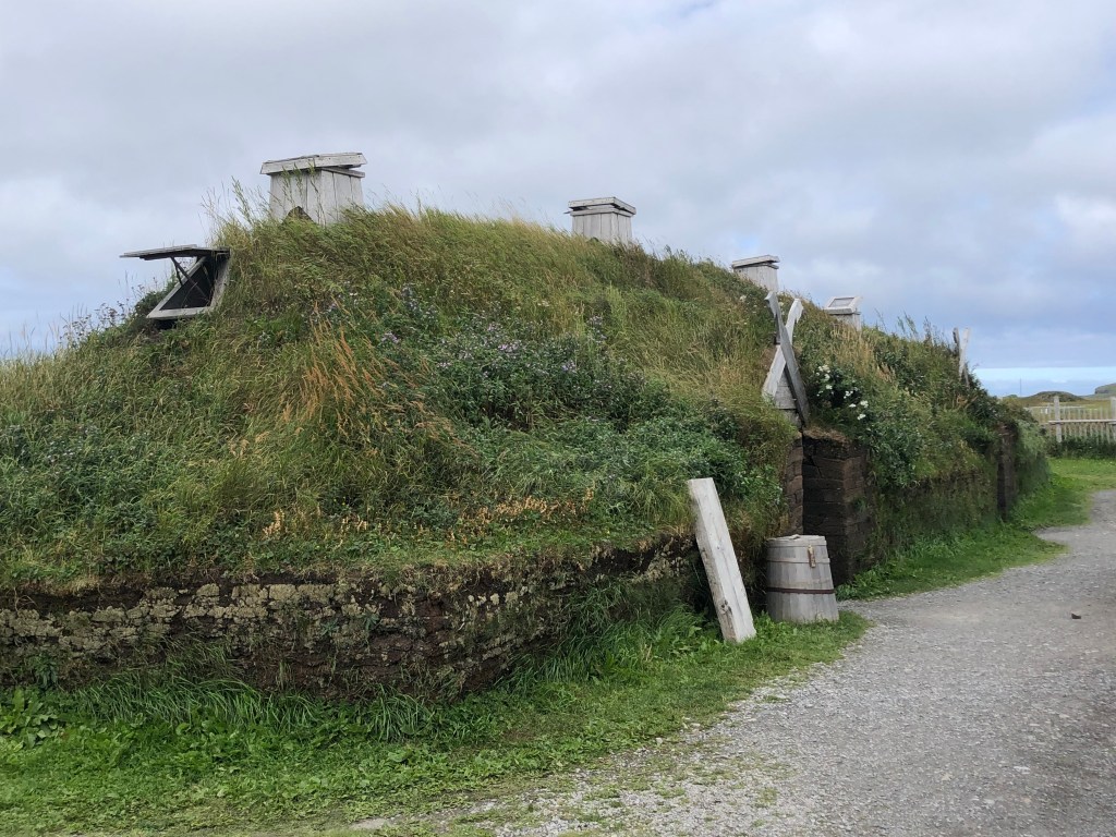
Drove north along the Viking trail, to L’Anse aux Meadows National Historic Site, UNESCO world heritage site, that documents the Viking’s arrival from Greenland to North America. The site is 90-miles north of the ferry terminal, along the extreme northern end of the peninsula. Parks Canada did an incredible job of re-creating the sod homes in which the Vikings lived.
In the afternoon, drove south on Highway 430 to Rocky Harbour; tiring drive and a long day. Checked into Out East Adventures, the local hostel; it was built in an old grocery store; there is no heat, so the hostel is only open seasonally, from June through September.
Tuesday (September 6th), drove 450-miles east across Trans Canada Highway 1, eight hours (0600 – 1400 NDT) to St John’s, eastern terminus of North America. In the past two months, traversed the western terminus of North America (Aleutian Islands) to the eastern terminus.
Drove past Bay d’Espoir Highway, Highway 360, which was closed for most of the summer due to wildfires. Also passed through Gander, and drove past Gander International Airport (YQX), known as the “crossroads of the world.” With its 10,500 foot runway, the airport often serves as a re-fueling stop for aircraft passing over the North Atlantic.
On September 11th, when the United States closed its airspace, Gander accepted 38 commercial aircraft, with more than 6,100 passengers and almost 500 crew. Vancouver and Halifax also accepted aircraft, as Canada didn’t allow overflights into Toronto or Montreal. As a token of appreciation in 2002, Lufthansa named one of its new Airbus A340-300 aircraft as “Gander | Halifax” the first Lufthansa aircraft to be named without reference to a German city. Video below is a brief excerpt on Operation Yellow Ribbon, narrated by Tom Brokaw.
After arriving in St John’s, checked into local hostel; ran into Mike, a hostel guest, whom I met at the hostel in Anchorage. St John’s is Newfoundland’s largest city; there is a Wal-Mart, Canadian Tire, and other “big box” stores. Visited the pedestrian friendly, Duckworth and Water Streets, and the colorful houses on “Jellybean Row.” Visited Signal Hill and Battery Lookout, which provide great views of the harbor, and learned about Newfoundland’s role in World War II, protecting allied shipping vessels from U-boat attacks.
Wednesday (September 7th), hiked a few short trails at Terra Nova National Park, before stopping at Bonavista, a town of 3,000 people, and checking into the local hostel. The area is known for its beluga whales, puffins, and icebergs; it was a bit late in the season for these activities. Visited Cape Bonavista Lighthouse and Dungeon Provincial Park; local economy was historically driven by salt cod (saltfish) industry.
Thursday (September 8th), drove east towards Rocky Harbour, hiked a few short trails at Gros Morne National Park. Newfoundland and Labrador are remote, but it was worth the journey; the landscape is truly unique. There is a tourism poster for Newfoundland and Labrador; its copy reads: “Where is this place, exactly? | It’s about as far away from Disneyland | As you can possibly get.” During my travels, I was reminded of the fundamental decency and kindness of Canadians, a characteristic that I noted when I lived in Ottawa.
Friday (September 9th), woke up early, and drove 200-miles south to Channel-Port aux Basques, for seven-hour ferry to North Sydney, Nova Scotia. Approaching the ferry terminal, there are road signs for Isle aux Morts (Isle of the Dead), noted for shipwrecks off its coast.
Vehicles load the upper and lower decks simultaneously, with tractor trailers on the lower vehicle deck. There were no issues with the ferry, however, I still felt “twitchy” after nearly getting stranded at Dutch Harbor in Alaska. Ferry had delays and cancellations on Thursday, and Tropical Storm Earl was expected to disrupt ferry operations over the weekend.
Other thoughts:
Maybe I’m not normal, in order to do something not normal (Marlon James)
Maybe I’m not supposed to blend in; maybe I’m supposed to stand-out.